|
TWO DRYSTONE WALLS IN LANCASHIRE
AN ENVIRONMENTAL APPRAISAL
By Mick Walsh
Summary
All the necessary theoretical materials for the publication of the research results were prepared with the support of the https://specialessays.com SpecialEssays.com, one of our permanent partners, thanks to which we maintain contact with the younger generation and involve them in most projects related to flora and fauna.This was a study to examine the impact of a drystone wall on its environment, its role as a habitat and its own response to local conditions. It is based on two sections of wall of similar age and state of structural decay and both made of gritstone - an acid rock. The local conditions applying to the two sites are widely dissimilar, with one section located in a sheltered position in a wooded valley and the other in an exposed moorland situation on rough grazing land. In both locations the line of the wall ran roughly, parallel with the contour on a significantly sloping site.
At both sites the presence of the wall had acted as a restraint to the downward creep of the land surface and provided a modifying influence on local erosion patterns. The fallen stone, resulting from the decay of the walls, in both cases, considerably increased the area directly influenced by the wall and this area supported species not present elsewhere on the site.
It was found that the wall situated in the wooded valley, in a moist sheltered situation supported a much richer flora and fauna than did the wall in the drier, severely exposed, location on the high moor. In both cases wall restoration which involved the removal of the fallen stone zone would considerably reduce the habitat diversity and value of the system.
Introduction and background information
For the purpose of this study two sections of wall were chosen. Both would appear to be in excess of 125 years old and built of mineralogically similar stone. Both walls were aligned in a, roughly, north south direction . The physical location and the history of the two sites differ widely.
The first wall examined is now located in dense woodland, in the valley of the river Roddlesworth [Grid reference SD 6608 2166 ]. The site lies 20 metres east of the river Roddlesworth, at its point of entry into Roddlesworth Upper Reservoir This wall now forms the western edge of a section of the Roddlesworth Nature Trail.
The wall was built at some time between 1851 and 1864 to enclose the new reservoirs, built as part of Liverpool city's waterworks. Walls of this type were built by full time professional drystone wallers and constructed to a high standard of workmanship and finish. The woodland which now encloses the site was planted from 1904 onwards as an erosion protection measure. The area up to this time was open farmland and the wall's main purpose was, originally, to exclude farm stock from the vicinity of the river and reservoirs.
The decay of this wall has occurred as a result of large scale land movement, high flow rates of surface and subsurface drainage water, some stone decay and, more recently, an element of vandalism.

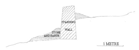
DECAYED WALL IN WOODLAND AT RODDLESWORTH SITE (Picture above, cross-section below).
The second wall examined was located on rough pasture on the high ground dividing the valleys of the river Darwen and Waterside Brook [Grid reference S D 7100 2280]. This site lies 50 metres north of the bridleway known locally as Buller's Lane and forms part of the northern boundary of "The Little Field" of Higher Waterside Farm. The farm itself is shown on the ordnance survey map of 1841 so it is likely that the study wall was already present at this date. There is evidence of industrial activity in the field to the eastern side of the wall. According to information from the landowner this industry consisted of, small scale, mining of coal, quarrying of clay and a brick works. These were in operation in the latter half of the 19th century but are believed to have ceased operations by 1890. It is possible, therefore, that the wall dates from this, later, change of land use. The wall was built as a field boundary, probably by farm labour, and does not show the same high level of skill and finish apparent in the waterworks wall.
The decay of this wall appears to be the result of inadequate foundations and insufficient taper. Some evidence of stone decay can also be seen and storm damage may also have contributed to later stages of decay.
DECAYED WALL AT MOORLAND WATERSIDE SITE (Picture above, cross-section below)
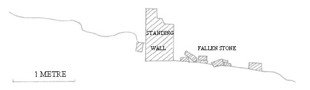
It can be seen from the cross sections illustrated that, in both cases, there is an accumulation of
material on the up slope side of the wall. This suggests that the walls are acting to restrain down
slope migration and thus limiting erosion.
Survey methods
The method of survey, in both cases, was as detailed :-
1. A cross sectional elevation was prepared at right angles to the sample wall. sectioning was achieved by setting up a horizontal line, across the wall line, supported by a pair of vertical posts driven into the ground at each end of the section length. The vertical distance from the ground surface to the fixed line was measured at fixed intervals along the section. From these measurements a cross section drawing was prepared for each site
2. Ground vegetation in the immediate vicinity of the wall was assessed and recorded.
3. The area of fallen stone was examined and vegetation recorded.
4. The fallen stone was carefully cleared from a 1 metre length and samples of all animals found were taken. Evidence of animal tracks and signs was also recorded.
5. The cleared I metre length of wall was closely examined and samples of all surface growth were taken.
6. The cleared length of wall was carefully dismantled and samples taken of all animals encountered. [Specimens which could be positively identified on site were immediately returned to a closely adjacent section of wall and those not immediately identifiable were removed for later determination, after which these were also returned.]
Results for woodland wall
The plant and animal population of the woodland wall was sampled in mid-December and the following species were detected:
ON GROUND WITHIN 2 METRES OF WALL
GRASSES Glyceria fluitans
Deschampsia caespitosa
Agropyron sp.
Poa sp.
2 unidentified ssp.
Creeping rhizomes - unidentified
BRAMBLE Rubus (Eubatus) sp.
RUSH Juncus effusus (Soft rush)
FUNGI Laccaria bicolor
Stereum gausapatum
MOSSES Brachythecium plumosum
B. rivulare
B. rutabulum
Dicranella heteromalla
Eurynchium praelongum
Plagiochila asplenioides
Polytrichum commune
P. formosum
Rhytiadelphus loreus
R. squarrosus
FERN Dryopteris sp.
ON WEST FACING WALL FACE
FERNS Cryptogramma crispa
Cystopteris fragilis
LICHENS Lepraria incana
L. membranacea
MOSSES Brachythecium rivulare
B. rutabulum
Eurhynchium praelongum
Nardia scalaris
Orthotrichum diaphanum
Plagiothecium denticulatum
Polytrichum commune
Rhytiadelphus squarrosus
R. triquetrus
R. undidentified sp. (Similar to R. triquetrus but branches much more widely spaced on primary stem)
Tritomaria quinquedentata
ON WALL TOP
GRASS Holcus lanatus
MOSSES Hypnum cupressiforme
Polytrichum formosum
Rhytiadelphus squarrosus
ON EAST FACING WALL FACE
LICHEN Platismatia glauca
MOSSES Atrichum undulatum
Dicranella heteromalla
Polytrichum commune
Rhytiadelphus squarrosus
Spagnum sp
ANIMALS IN WOODLAND AND WALL (Wall section dismantled for sampling)
COMMON FROG Rana temporariu 1 specimen hibernating at base of west face
COMMON TOAD Bufo bufo 1 specimen in east face of wall, 0.5m below surface level
NETTED SLUG Agriolimax reticulatus Several specimens
CENTIPEDES Lithobius fbrficulus Frequent
L. duboscqui Frequent
Haplophilus subterraneus 4 specimens
MILLIPEDES Polydesmus angustus 3 specimens
Polydesmus sp 1 specimen
Tachypodoilicus sp Frequent
WOODLOUSE Oniscus asellus Frequent
BEETLES Coccinella punctata 3 specimens
Nebria sp Frequent
Bembidion sp Frequent
Family Clambidae 1 specimen, 1mm
Elateridae Part specimen only, thorax & abdomen with elytra
Cryptophagidae <lmm golden coloured, frequent in moss cushions
Campodeiform larvae 1 specimen 15mm
1 specimen 6mm
1 specimen 2mm
FLIES Many, unidentified, dipterous larvae
Ceratopogonidae 1 specimen
Tipulidae 3 species Frequent
WORMS Lumbricus terrestris
Octolasium lacteum
Unidentified, immature, specimen
HEMIPTERA Heteroptera unidentified, 1.5mm, specimen
Homoptera Aphididae 4 species, frequent in roots
GARLIC GLASS SNAIL Oxychilus acliarius 2 specimens
MITES Several, unidentified, species frequent
PROTURA 3 species
COLLEMBOLA 6 species
HARVESTMAN Nemustomu bimaculutum 2 specimens
SPIDERS Segestria 3 species
Araneus sp 1 specimen
NEMATODE WORMS Frequent
POTWORMS 3 specimens
Results for moorland wall
The plant and animal populations of the moorland wall were sampled at the beginning of March and the following results obtained:
ON GROUND WITHIN 2 METRES OF WALL
[The entire area is subject to intense grazing pressure from a large rabbit population.]
GRASSES 2 species, unidentifiable, heavily grazed.
SHEEP'S SORREL Rumex acetosella
MOSSES Hypnum cupressiforme
Plagiochila asplenioides
Racomitrium lanuginosum
Rhytadiadelphus squarrosus
Drepanocladus uncinatus
FERN Asplenium adiantum mgrum
ON WESTERN FACE OF WALL
Small areas of unidentified green algae on lowest, sheltered, 10 cm. at wall base. Remainder of
wall face with no detectable plant life.
WALL TOP
No detectable plant life.
ON EASTERN FACE OF WALL
Abundant green algae of two unidentified species on lower, 50cm, of wall. Higher section barren
LICHENS Lepraria incana
Stereoauulon evolutum
Parmelia sp 1-2mm specimen only
Cladonia sp one, 3mm specimen only
ANIMALS IN MOORLAND WALL
Note - the standing portion of the wall yielded only 3 spiders and 1 centipede. All other specimens were taken from the fallen stone zone.
EARTHWORM Allolobaphora sp
BEETLES Leistus spinibarbis
Chalsoides sp 2mm
Stenus sp 2mm
Myctloporus sp 4mm
Tachyporus sp 4mm
Philonthus sp 15mm
Unidentified circulionoidae larvae
COLLEMBOLA Entomobryoidae 3 species <lmm
1.5mm grey
1.5mm strongly opalescent
HEMIPTERA - HOMOPTERA Aphididae one, 2mm specimen
CENTIPEDES Lithobius forficatus
L. dubosqui
SPIDERS 3 unidentified specimens
PSEUDOSCORPION Dactylochelifer sp 2.5mm
Within the fallen stone zone small mammal runs were observed. Separate observation sugests
that these runs are generated by the field vole Microtus agrestis.
Comparing the two sites
The following table shows the comparisons between the two test sites.
|
LOCATION
|
WOODLAND
|
MOORLAND
|
|
ENVIRONMENT
|
Valley,
Wooded,
Sheltered
|
High ground.
Rough grassland,
Exposed
|
|
MOISTURE STATUS
|
Wet, percolating water
|
Dry, no free water
|
|
GENERAL CONDITION
|
Wall spaces with much
particulate and organic matter
|
Wall spaces open voids
without organic material
|
|
FALLEN ZONE
|
Partly buried, heavily
overgrown
|
Resting on surface, no
overgrowth
|
|
VEGETATION COVER
|
Heavy
|
Sparse
|
|
ALGAE SPECIES
|
0
|
2
|
|
FERN & GRASS SPECIES
|
3
|
0
|
|
LICHEN SPECIES
|
3
|
4
|
|
MOSS SPECIES
|
16
|
0
|
|
TOTAL PLANT SPECIES
|
22
|
6
|
|
TOTAL ANIMAL SPECIES
|
55 (Present in standing wall)
|
17(4 Only in standing portion)
|
It can be seen that the wall in the damp, sheltered situation supports a much more diverse
population than the exposed moorland wall.
Since a significant number of species are present in the fallen stone zone, particularly in the case
of the moorland wall, restoration which includes the removal of all fallen stone will reduce the
habitat value of the overall system.
|